Week 3
Topic: Satellites
Introduction

In space, it is often difficult to decide which is the “satellite” in a pair of bodies. This is because all objects that have mass (quantity of matter in a body) are affected by gravity. The motion of the primary object is also affected by the satellite.
Meaning of Satellite
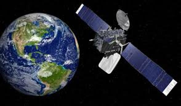
A satellite is an object that revolves round another object (which is known as its primary). Satellites can be man made or may be naturally occurring such as moons, comets, asteroids, planets, stars and even galaxies.
An orbit is the path that an object makes around another object while under the influence of a source of centripetal force, such as gravity.
Orbits were first analyzed mathematically by Johannes Kepler who formulated his results in his three laws of planetary motion. Isaac Newton demonstrated that Kepler’s laws were derivable from his theory of gravitation and that, in general, the orbits of bodies responding to the force of gravity were conic sections.
Newton showed that a pair of bodies follows orbits of dimensions that are in inverse proportion to their masses about their common centre of mass. Where one body is much more massive than the other, it is a convenient approximation to take the centre of the mass as coinciding with the centre of the more massive body.
Nigeria SAT 1
Nigeria SAT 1 means the first Nigerian satellite sent into orbit. It was launched on 27th September 2003, abroad a Russian rocket. The satellite is to monitor water resources, soil erosion, deforestation and disasters. It will also used to survey oil pipelines, and prevent oil theft and smuggling activities. In specific terms, the satellite is expected to boost expansions in communication, agriculture, security surveillance and government is expected to earn 200 million US Dollar annually from subscriber Africa nations.
Nigeria SAT 1 can image scenes as large as 640 x 560 km, providing unparalleled wide-area, medium-resolution data. The data will be used within Nigeria to monitor pollution, land use and other medium-scale phenomena. Besides, satellites are now regarded as the workhorses of communication, weather forecasting, intelligence gathering, population survey and a host of other services that have become vital aspects of human development.
Uses of Satellite
Satellite serves the following purposes:
- To give advance warnings of natural disasters like floods, earthquakes, volcanic eruptions and storms
- To warn against or manage occurrence of man-made disasters like oil pollution, desertification, erosion, forest fire and deforestation
- In agriculture, for mapping, land use, planning, management of sustainable grazing, forest logging, planning afforestation programmes, crop inventory and yield forecast
- Water resources development and management, including assessment of the quantity and quality of surface and underground water, rainfall prediction, as well as integrated water resources management on drought and other disaster forecast
- Solid mineral exploration and exploitation, including general geological mapping and map update or revision, as well as differentiating host mineral areas in oil, gas and sold mineral exploration
- For monitoring the Ecosystem. Evaluation and monitoring of vegetation and land use as well as the aquatic system
- Local and regional planning for tourism and its potentials
- Demographic uses such as mapping and planning of population surveys, census enumeration areas, as well as mapping, planning and monitoring of rural and urban growth.
- Mapping of state and international boundaries, planning and mapping of terrain for defense and security purposes, as well as identification of international criminals
- In public health delivery to establish the relationship between malaria vectors and the environment that breeds malaria, while its remote sensing technology can be used to give early warning signals on future outbreaks of meningitis
- To provide the technology needed to bring education to all parts of the country via distant learning
- It is used as communication satellites which are artificial satellites stationed in space for the purposes of telecommunications
- Navigation satellites are satellites which use radio time signals transmitted to enable mobile receivers on the ground to determine their exact location. The relatively clear line of sight between the satellites and receivers on the ground, combined with ever-improving electronics, allow satellite navigation systems to measure locations to accuracies on the order of a few metres in real time. The exact location can be found by the use of geographical information system (GIS)
